Archifdy Ceredigion Archives
ACM: Early maps of Cardiganshire
Acc. 3392
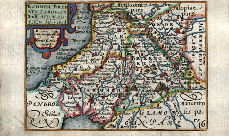
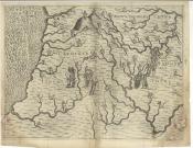
Ref: ACM/1-11SAXTON'S SURVEYACM/1 'Radnor Breknok Cardigan et Caermarden, quatuor australis Cambriae comitatuum (B. Deheubart. A. South Wales) description. Ano. Dni 1578', Christoferus Saxton descripsit'.
The earliest printed map of the county. In
An Atlas of England and Wales (1579). Shows rivers, lakes, forests and principal places. Relief indicated by 'molehills'. Royal arms and those of Thomas Seckford, Saxton's patron, scale of miles and cardinal points given in border. Ships and sea monsters. Coloured.
M.G. Lewis No. 1.
55 x 42 cm
ACM/2 'Radnor Breknok Cardigan et Caermarden, quatuor australis Cambriae comitatuum (B. Deheubart. A. South Wales) description. Ano. Dni 1578', Christoferus Saxton descripsit'.
In
An Atlas of England and Wales (1579). Coloured.
M.G. Lewis No. 1.
55 x 42 cm
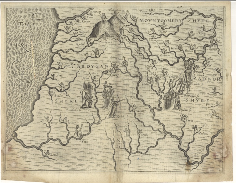
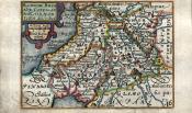
DRAYTON'S SURVEYACM/3Michael Drayton, 'CardyganShyre, Mountgomery Shyre, RadnorShyre', in
Polyolbion: Great Britaine (1612), Number 87, top right, links the map to the sixth song on p. 87 of the volume. Shows rivers, forests and mountains with their personifications, respectively naiads or nymphs, huntresses and shepherds.
Map and names of rivers, forest and hill (Plynlimon), derived from Saxton's map (ACM/1-2), presumably together with his map of Montgomeryshire.
M.G. Lewis No. 5.
33.9-35.1 x 27.2-6 cm
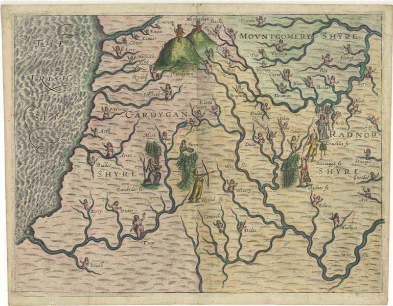
ACM/3 (1612)
Michael Drayton, 'CardyganShyre, Mountgomery Shyre, RadnorShyre', in
Polyolbion: Great Britaine (1612), but lacking the number 87 that linked it to the sixth song on p. 87 of the volume. Coloured.
Reprint of ACM/3?
34-5 x 27 cm

ACM/4 (1612)
Peter Keer, 'Radnor Breknok Cardigan et Caermarden descript', p. 419 of William Jansson Blaeu's
Guilielmi Camdeni, Viri Clarissimi Britannia, sive florentissimorum Regnorum Angliae, Scotiae, Hiberniae, & Insularum adjacentium (1617). Shows principal rivers, mountains and places. p. 420 of Latin text on reverse.
Reprint of map dated 1605-10, one of a series of miniatures based on Saxton's map (No. 1/2) 14 x 9-9.3 cm
ACM/6Peter Keer, 'Radnor Breknok Cardigan and Caermarthen described', '46', in
England Wales Scotland and Ireland described... abridged (from J. Speed) (1620/1627). Description of Pembrokeshire on reverse.
Reprint of ACM/5 with title in English
M.G. Lewis No. 8.
14.5 x 9.1 cm
ACM/7Peter Keer, 'Radnor Breknok Cardigan and Caermarthen described', '46', in
England Wales Scotland and Ireland described... abridged (from J. Speed) (1627). Coloured.
Reprint of ACM/5
M.G. Lewis No. 8.
15.3 x 9.7 cm
ACM/7 (1627)
Peter Keer, 'Radnor Breknok Cardigan and Caermarthen described', '46', in
England Wales Scotland and Ireland described … abridged, from J. Speed (1676). Shows principal rivers, mountains and places. Description of Pembrokeshire on reverse.
Reprint of ACM/6 or ACM/7.
M.G. Lewis No. 25.
14.5 x 9.1 cm
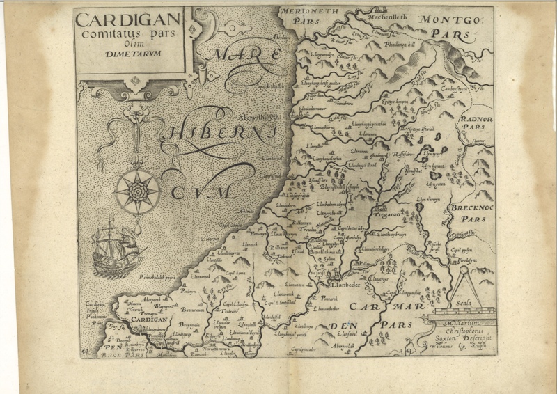
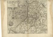
KIPP'S SURVEYACM/9William Kipp, 'Cardigan, comitatus pars olim Dimetarum', 'Chrisphorus Saxton Descripsit', in Camden's
Britannia (1607). Shows rivers, lakes, forests and principal places. Relief indicated by 'molehills'. P. 518 of Latin text on reverse.
Two places depicted with gabled buildings on Saxton's 1578 map, Aberdyfi ('Aberdovye') and Ffair Rhos ('Rossefaire') are distinguished here by appearing as dots, rather than the usual 'place' symbol.
Derived from or based upon Saxton's map (ACM/1-2)
M.G. Lewis No. 2.
41.5 x 32 cm
ACM/10William Kipp, 'Cardigan, comitatus pars olim Dimetarum', 'Chrisphorus Saxton Descripsit', in Camden's
Britain or a Chorographicall Description of England, Scotland and Ireland (1610). Coloured.
Reprint of ACM/9.
M.G. Lewis No. 3.
37 x 32.5 cm
ACM/11William Kipp, 'Cardigan comitatus pars olim Dimetarum', in W. Camden's
Britain or a chorographicall description of England, Scotland, and Ireland … (1637).
Reprint of ACM/9.
M.G. Lewis No. 12.
40-42 x 31.8-32.3 cm
ACM/11 (1637)