

Researching house history
In general, it is easier to trace a property through the lives of its inhabitants; indeed, it is frequently the only way, unless it was once part of a landed estate (more on that later). It is, however, more likely that the researcher will have to resort to other means to research a house’s history. A variety of records may be consulted, and the following might yield useful information.
- The Census – a count of the population taken every 10 years from 1841 onwards - records the name of the inhabitants of a building, if of course the building existed at the time the census was taken. The information recorded varies from census to census, from fairly minimal in 1841 to 1911 which even records the number of rooms.
- Monumental Inscriptions. In Ceredigion, these have been recorded for most of the county by Dr E.L. James and Dr M.A. James and copies are available in Ceredigion Archives. They are indexed by the names of the deceased and also by place-names which might give us further clues as to who might have lived in the property.
- Electoral Rolls and registers which would provide the names of those eligible to vote (20th century).
- The 1910 Land Valuation maps (in the National Library) and schedules (in Ceredigion Archives). This survey recorded the value, use and ownership of properties which existed around 1910.
- Iwan Wmffre's The Place-Names of Cardiganshire (British Archaeological Reports), available for consultation in Ceredigion Archives: three volumes of some 15,000 place-names in Cardiganshire, containing references to their appearance in records available in the National Library – manuscripts, maps, estate records, and parish registers (now in Ceredigion Archives – see below).
- Parish registers of baptisms, marriages and burials - from 1813 there was a column in these registers to note 'abode'; this can sometimes help to establish when a house was built.
- Tithe Maps should give you details of the owner and the occupier of lands and properties c. 1840. This will help determine whether there are likely to be surviving title deeds in an estate collection – see below.
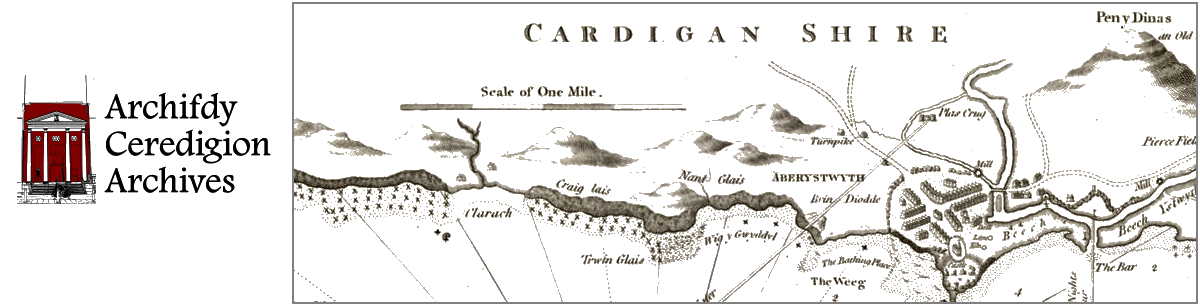
- Ordnance Survey County Series maps (25 in/mile) show footprints of buildings as well as house and farm names. They can help establish whether a building stood on the site by the date of the first or second edition (1870s and c. 1900 respectively), or if it was built in the period between these dates. The older OS maps (c. 1834) have less detail but may also be useful.
- In estate collections one might find legal documents relating to the whole estate or its component parts, such as mortgages, leases, tenancy agreements, abstracts of title and more. When the whole estate is affected, for example when it is mortgaged to raise money, names of houses and their present and former tenants are often given together with acreages, rateable values, and other information. A lease or a tenancy might include a map of the property, and plans of houses to be erected. There may also be correspondence between the landowner or his representative and the tenants. An estate collection might also have rent rolls which would show to whom a property was leased on an annual basis.
Website developed by Technoleg Taliesin